

Slocan Lake foreshore survey report now available
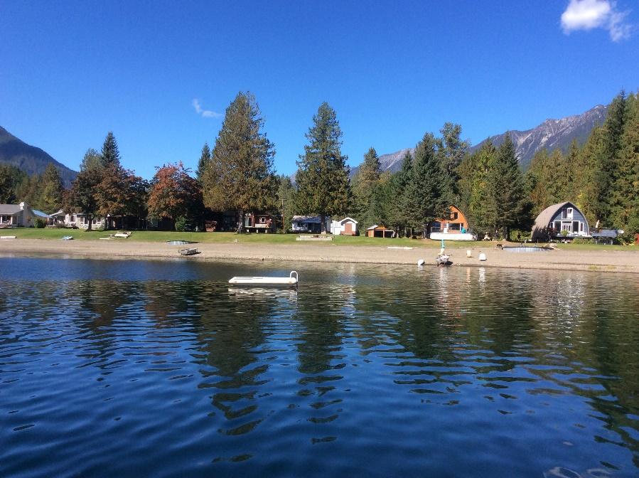
Photo from the 2021 Slocan Lake FIMP lake survey. LLC Photo
As the popularity of Slocan Lake grows, both as a recreational hotspot and a scenic place to live, monitoring the lake’s foreshore is just as important as monitoring the lake’s water quality.
The lake foreshore is defined as the area along the lake between the low and high water mark, and is extremely valuable ecologically, culturally and economically. Around ninety percent of all lake biodiversity is found in the foreshore; it provides habitat for fish, nesting waterbirds, breeding amphibians, shorebirds and more. Indigenous archaeological and culturally significant sites may be found there. Erosion, flooding, and waves all impact the foreshore, and can cause expensive property damage.
Negative impacts and changes to lake foreshore can occur slowly over time and can also be difficult to detect. Living Lakes Canada has studied the foreshore of Slocan Lake using a federal monitoring protocol called Foreshore Integrated Management Planning, or FIMP. This was done in 2010 and again in 2021 to determine how much the lake foreshore health had changed over the years. The monitoring can also highlight the effectiveness of lake management policies implemented by all levels of government as well as considering important Indigenous cultural values, species risk and their habitat.
“The purpose of a FIMP re-survey is to return to a lake roughly 10 years after the first survey and assess the rate of change in urban development and ecological parameters, and to audit the best management practices and guideline compliance along the shoreline,” said Georgia Peck, FIMP Manager with Living Lakes Canada. “Slocan Lake was recognized as a priority lake due to the presence of species at risk and it having been previously surveyed in 2011.”
The foreshore survey was done by boat using GPS and aerial photograph assessment, and 88,566 m of the Slocan Lake shoreline was surveyed. The comprehensive survey cataloged multiple observations: land-use (industrial, residential, commercial), shore type (cliff/bluff, rocky shore, sand beach), foreshore condition, the number of docks, weirs or other man-made developments, wildlife, vegetation, and many others.
The 2021 Slocan Lake FIMP findings can be found in a report in the Columbia Basin Water Hub database, including updated Slocan Lake Foreshore Development Guidelines.
“The Foreshore Development Guidance document is a resource that can be referenced by government, First Nations, stewardship groups, property owners, or anyone wishing to learn more about the quality of habitat on the foreshore along with the evidence-based development guidelines,” said Peck.
A comparison between the 2010 and 2021 surveys indicates that the Slocan Lake foreshore areas have remained relatively unchanged over the past 11 years (0.01% rate of change per year and only 80 m observed as newly disturbed). The majority of the shoreline was classified as having a low level of impact (67,016 m; 76%), followed by no impact (9,105 m; 10%), high impact (7,186 m; 8%) and medium impact (5,259 m; 6%) level of impact. Fish sampling conducted in shallow water habitats of Slocan Lake in September 2021 observed Shorthead Sculpin (Cottus confusus) — a fish species of Special Concern under the federal Species at Risk Act (SARA) and provincially blue-listed — at the south end of Slocan Lake and near the outlet of Springer Creek. Traditional Ecological Knowledge was incorporated directly into the assessment and inventory of shoreline observations and a report was produced with recommendations for the long-term protection of important habitats and cultural values.
“FIMP has provided us with the confirmation that 90% of the shoreline is still in a natural state, with the majority of the Slocan Lake shoreline ranked as high ecological value. This information will contribute to updating the RDCK Water Development Permit requirements in the Official Community Plan for Slocan Lake North, slated for revision commencing in the fall of 2022,” said Wendy King, president of the Slocan Lake Stewardship Society. “The FIMP survey and Foreshore Development Guidelines complements our existing knowledge and directly supports the process of identifying ecologically sensitive zones.”
Living Lakes Canada entered a four-year Contribution Agreement with Fisheries and Oceans Canada (DFO) and their Canada Nature Fund for Aquatic Species at Risk Program in 2019 to review and revise the FIMP methodology and map or re-map up to eight lakes. To date, five lakes have been re-surveyed and two additional lakes have been surveyed through the DFO-funded program.
To learn more, visit fimp.cbwaterhub.ca or email georgia@livinglakescanada.ca.

