PROGRAM GOAL
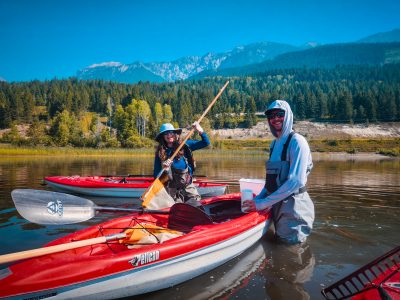
Living Lakes Canada, in collaboration with the Columbia Wetlands Stewardship Partners (CWSP), is monitoring ecological restoration of nearly 200 kilometres of the Upper Columbia River and its associated network of floodplain wetlands to ensure sufficient water flow to this vital ecosystem. The aim is to increase the ecosystem functionality of the Columbia Wetlands.
OVERVIEW
The Columbia Wetlands in southeastern British Columbia are among North America’s longest, intact wetlands systems and contain the only undammed section of the 2,000-kilometre-long transboundary Columbia River. This 26,000-hectare, Ramsar-designated wetland of international importance is also vulnerable to climate change. Living Lakes Canada and the Columbia Wetlands Stewardship Partners (CWSP) have observed drying trends in this crucial ecosystem.
To address these impacts, potential restoration sites have been identified. Using Beaver Dam Analogues, this restoration work will help store water on the landscape to mitigate drought and enhance biodiversity. Monitoring before and after restoration activities will help demonstrate the effectiveness of the project.
Alongside public outreach on project findings, Living Lakes supports hydrometric monitoring, eDNA sample collection, wetlands inventorying, and restoration site identification.
Data collected through this program feeds into Living Lakes Canada’s Columbia Basin Water Monitoring Framework (CBWMF). CBWMF is a large-scale hydroclimatic monitoring network across five areas throughout the Canadian Columbia Basin, including in the Columbia-Kootenay Headwaters hydrologic region where the Columbia Wetlands are located. A broader understanding of climate impacts on water across the region will provide additional insights on the state of the Columbia Wetlands.
PROJECT PARTNERS
Key to this work is engaging project partners, including First Nations governments and communities, and co-developing long-term strategies for restoration and monitoring programs.
Central to this project is consultation with the Shuswap Band for input on various activities including permitting as well as active monitoring before, during, and after project implementation. The Shuswap Band highly values the natural environment in the Columbia Valley (location of the river’s headwaters and where Band members have a physical, cultural, and emotional attachment to the various wetlands and wildlife. For many years the Shuswap Band have been concerned about the loss of salmon, the decline of fish and wildlife and the changes in the wetlands.
BACKGROUND
As part of the Pacific Flyway, one of North America’s four major migratory routes, the mosaic of wetland types within the Columbia Wetlands provides a safe haven for over 160 species of migratory birds including at-risk Tundra Swans. This invaluable ecosystem also provides a cornucopia of benefits to surrounding communities, including flood control, groundwater recharge, irrigation needs, water purification, and carbon storage.
The Columbia Wetlands is a remarkably productive and biodiverse ecosystem characterized by the seasonal flooding of the Upper Columbia River. Because this section of the river from Canal Flats to Mica Dam north of Golden is free-flowing, the seasonal flood regime generates the ‘pulse’ of this ecosystem which remains largely unaffected by human development.
Although the Columbia Wetlands are Ramsar-designated and internationally recognized, approximately 40% of this pristine floodplain remains unprotected. Vulnerable to climate change impacts, ongoing research shows that the Columbia Wetlands are drying.
One indicator is that water-loving plants are being replaced by willow, a plant that requires less water. Over the last 39 years, the spread of willow has doubled in the wetlands, pointing to a drying landscape. Wetlands that once held open water all year long are now often dry in the winter and spring. Now, migrating birds are left with fewer options to rest and feed during long journeys. In fact, certain tracts of the Columbia Wetlands have lost over 16% of its permanent open water area in the last few decades.
CONTACT
Paige Thurston, Columbia Basin Water Monitoring Framework Program Manager cbwmf@livinglakescanada.ca
Banner photo by Columbia Wetlands Stewardship Partners.

News and Updates
Columbia Wetlands drying up – CBC Vancouver News, Jan 27 2024
‘Playing beaver’ in drying of the wetlands – Columbia Valley Pioneer (page 14), Nov 23 2023
Shining a spotlight on a Canadian star for World Wetlands Day – Living Lakes Canada, June 25 2023
New restoration program focusing on fish passage, Columbia Wetlands – Living Lakes Canada, Jun 25 2021
Mitigating Hydrologic Vulnerability in the Columbia River Wetlands – Living Lakes Canada, Jun 8 2021
Living Lakes Canada featured in special Francophonie publication on the world’s ecosystems and wetlands – Living Lakes Canada, May 26 2021 (focus on Columbia Wetlands)
Setting up a water monitoring system for the Columbia Wetlands – Living Lakes Canada, June 16 2020
For a complete list of news features, visit our In The News page!


