PROGRAM GOAL
Kootenay Watershed Science (formerly known as the North Kootenay Lake Water Monitoring Project or NKLWMP) is working to improve understanding and prediction of how these small- and medium-sized watersheds are going to behave in a changing climate, especially in conditions of extreme high and low precipitation.
This program's data is available on the Columbia Basin Water Hub.

BACKGROUND
Kootenay Watershed Science (KWS) began as an initiative of the Kaslo and District Community Forest Society in 2007 and its transition to the KWS was initiated in 2012. An ongoing partnership between Living Lakes Canada and KWS was formed in 2017 to focus on collaborative funding, education, monitoring, rehabilitation and policy development initiatives for the long-term protection of Canada's lakes, wetlands and watersheds. In summer 2020, KWS joined forces with Living Lakes Canada and began operating as a program under the Living Lakes Canada umbrella. This program is supplying quality-controlled data to the Columbia Basin Water Hub open source database, currently being facilitated by Living Lakes Canada.
OVERVIEW
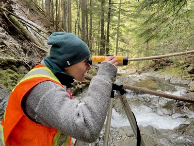
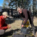
 The project has established seven hydrometric stations, two high-elevation snow course sites, two high-elevation climate stations and one low-elevation climate station on the north end of Kootenay Lake (click the map to enlarge view). These sites were strategically selected to complement existing regional monitoring sites. KWS follows monitoring protocols established within British Columbia and uses a blend citizen scientists and professional hydrologists to collect data and maintain the monitoring program.
LONG-TERM DATA
The quality-controlled data collected and analyzed by the project will provide decision makers with much needed information to guide critical conservation efforts, land use planning, development decisions, protection of water supplies, and forest management. The data can be used to improve prediction of flood frequencies, mass wasting events, and low water supply, as well as to reduce the risk posed by catastrophic events in a changing climate. The project will be working to build partnerships with data-users and community groups over the upcoming years.
FIND OUR DATA
- Columbia Basin Water Hub
- Aquatic WebPortal
- BC Snow Survey Stations - Stations: Purcell and Lost Ledge
SALT DILUTION GAUGING
Unsure of how salt can be used to measure flow rate?
Every body of water has a certain capacity to transfer an electric charge through it. This is what the term conductivity refers to. The salt content of water affects its conductivity. As salinity increases, so does conductivity. A conductivity meter tells you what the conductivity (i.e., salt content) of water is. By performing a calibration to assess how a waterbody reacts when salt is added (some water reacts slightly differently than others to an addition of salt) this data can be used to calculate the volume of water being moving down a creek in liters per second.
How does the KWS program use flow rate monitoring?
The KWS program operates eight creek flow monitoring stations in the north Kootenay Lake region. These stations are equipped with automated water level measuring devices. Using strategic salt dilution gauging, our KWS hydrologists chart out a relationship between flow rate and water depth. This relationship is called a Stage-Discharge Rating Curve and it allows us to predict flow rate (liters/second) based on the depth of the water in a stream. With this system, we can indirectly and automatically measure flow rates in streams.
ACKNOWLEDGEMENTS
KWS is grateful for the funders and volunteers who have made the project successful. Financial support has been provided by the Kootenay Lake Local Conservation Fund, Columbia Basin Trust, the Regional District of Central Kootenay, North Kootenay Lake-Kootenay Savings Fund (CFNKLS), the Healthy Waters Initiative (HWI), and the Columbia Basin Watershed Network (CBWN). In-kind support has been received from numerous local volunteers, Solinst, Aquatic Informatics, Fathom Scientific, and the Powder Bound Ski Club.
CONTACT
If you would like to learn more about KWS, please email paul@livinglakescanada.ca.
See Paul's profile.