PROGRAM GOAL
To pair local knowledge with water data to inform wildfire response in rural areas. Information gathered is compiled into interactive maps and shared with local emergency response organizations and British Columbia Wildfire Service.
WE WANT TO HEAR FROM YOU
We are currently delivering this project in the Lardeau Valley, Parson, Winlaw, and Grasmere and Yaq̓it ʔa·knuqⱡi'it First Nation. Local water knowledge is essential to this process. By applying our data in tandem with community knowledge, we are helping communities better prepare for wildfire response. Participation in this program is voluntary, and data from private lands will only be included with landowners' consent.
SHARE YOUR INPUT HERE
Lardeau Valley
See Project Area Map
The Lardeau Valley project area includes Cooper Creek, Meadow Creek, Marblehead and Howser and the interconnecting areas between the communities. This work is being carried out in partnership with Lardeau Valley LINKS. To share information about water sources for this project, complete this survey
Parson
See Project Area Map
The Parson project area includes McMurdo, Parson, Seeney, and Castledale. This work is being carried out in partnership with the Parson Community Hall. To share information about water sources for this project, complete this survey
Winlaw
See Project Area Map
The Winlaw project area extends from Pedro Creek to Lemon Creek, on the east side of the Slocan River. This work is being carried out in collaboration with SIFCo. To share information about water sources for this project, complete this survey.
Grasmere and Yaq̓it ʔa·knuqⱡi'it First Nation
See Project Area Map
The Grasmere/Yaq̓it ʔa·knuqⱡi'it project area extends north beyond the community of Grasmere to Canyon Cut-Off Road, and south to Roosville on the Canada/USA border. This work is being carried out in collaboration with the Yaq̓it ʔa·knuqⱡi’it Fire Brigade and Grasmere Community Society. To share information about water sources for this project, complete this survey.
HOW THE PROGRAM WORKS
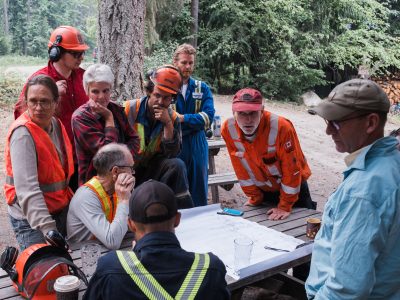
In each project area, a local organization acts as the Community Partner – they may also appoint an individual Community Champion. The Community Partner and Champion help the Living Lakes team to understand local priorities and context, and effectively engage with residents.
Local water knowledge is essential to these studies. At the start of each project, community members are invited to share water resources and other features to be included in the maps. Participation in this program is voluntary, and data from private lands is only included with landowners' consent.
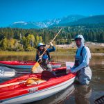
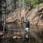
Following the community engagement and a review of existing data sources, the Living Lakes field team carries out site visits to take measurements at locations recommended by the community, and at additional locations discovered through field reconnaissance.
The resulting maps include locations and details about features such as:
- High-pressure standpipes
- Ideal pump-deployment locations in creeks
- Locations of buildings and residences
- Access routes
- Potential helicopter landing sites
The Living Lakes GIS team prepares these maps in several formats, so that they can be viewed using various apps and programs. Each point on the maps includes detailed information such as including location coordinates, landowner contact details, access instructions, water pressure and flow rates.
As these resources include information gathered on private properties, the complete professional versions are only shared with the Community Partner and relevant emergency response organizations, including BC Wildfire Service. A public version is shared more widely that omits sensitive information.
To learn more about this project, contact wildfire@livinglakescanada.ca.
BACKGROUND
This project is based on a pilot that was rolled out in 2023 in Argenta BC. The pilot combined Columbia Basin Water Monitoring Framework data with community knowledge and information from the Argenta Safety and Preparedness Society (ASAP) to map locations of water sources available for fire suppression. The resulting digital maps identified all available water sources in the community. Argenta was affected by wildfire shortly after the pilot project was completed, leading to the immediate use of the resources by BC Wildfire Service. The maps were acknowledged for helping to reduce the time spent carrying out field reconnaissance by firefighters. View the report developed for the community of Argenta in 2024 below.
Following this, many other communities became interested in replicating this project, leading to the program’s expansion.
CONTACT
If you have any questions regarding this program or are interested in getting involved, please contact wildfire@livinglakescanada.ca.
Banner photo by Louis Bockner.
News and Updates
Living Lakes water mapping program addresses Senate wildfire report recommendation – Living Lakes Canada, Jun 10 2026
Water mapping project to launch in East Kootenay this year – 102.9 Rewind Radio, Apr 2 2026
You can’t fight fire without water: Why B.C. needs to scale-up watershed mapping – Vancouver Sun, Aug 27 2025
Water source mapping could help in wildfire fight (2 min video) – Global News, Aug 17 2025
Water mapping helps rural B.C. communities prepare for wildfire response – Water Canada, Jul 7 2025
Living Lakes Canada launches water mapping projects in Slocan Valley to support wildfire response – Penticton Herald, Jun 18 2025
Resources
- Wildfire Suppression in Rural BC fuelled by proactive Water Mapping: Watershed Bulletin Volume 1 Issue 2 September 2024
- Red Mountain Road and Enterprise Creek Water Resource Inventory for Wildfire Suppression Report
- Red Mountain Road and Enterprise Creek Water Resource Inventory for Wildfire Suppression Map
- 2025 Impact Story - Strengthening Wildfire Preparedness One Map at a Time
Funders & Contributors
 |
 |
 |
|
 |
 |
 |
|
 |
 |
 |
 |
 |