

Introducing Kootenay Watershed Science
 Kootenay Watershed Science (KWS) is officially the new name for the long-running North Kootenay Lake Water Monitoring Project (NKLWMP) to better represent the project’s main goal: monitoring Kootenay watersheds.
KWS is working to fill the gap in hydrometric monitoring on small- to medium-sized watersheds in the West Kootenays to improve understanding and prediction of how these watersheds are going to behave in a changing climate, especially in conditions of extreme high and low precipitation. An initiative with roots dating back to 2007, KWS began operating as a program under the Living Lakes Canada (LLC) umbrella in summer 2020. This program is supporting the Columbia Basin Water Monitoring Framework that is under development and provides quality-controlled data to the Columbia Basin Water Hub open source database, facilitated by LLC.
Winter Recap
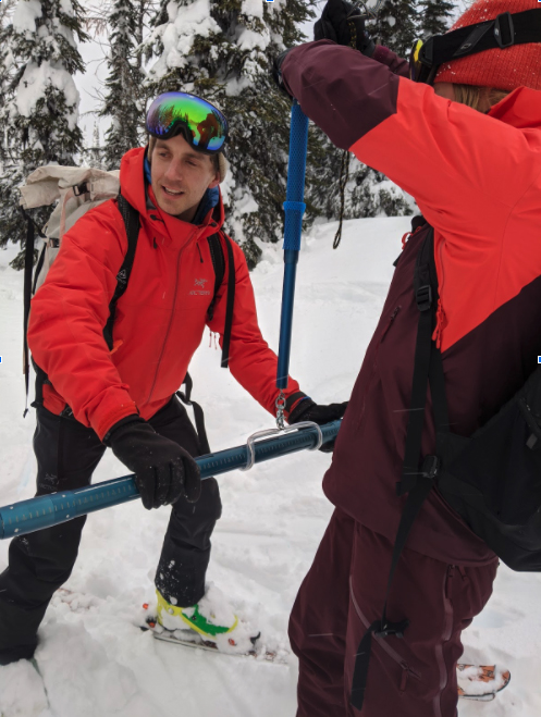
Over the winter months, the KWS team conducted snow surveys for two high elevation snow survey sites. These surveys measure the Snow Water Equivalent (SWE) of the snowpack at high elevation, which enables calculations of how much water will be released into our streams as it melts. It is useful information to help predict flooding, plan for spring runoffs, assess potential danger of floods, landslides and track changes in snowpack over time.
An overview of the KWS project and partner benefits was presented at Selkirk College’s virtual Bridging Silos conference that took place March 4 & 5 in the Day 2 session on the topic of ‘Bridging Silos through Local Partnerships: Reconceiving how local government, business, non-profits, and citizens can work together for effective climate action’.
Project partner Aquatic Informatics has included KWS in their sponsorship program, the Ripple Effect. Aquarius is an analytics software program that is used by Water Survey Canada, BC Ministry of Environment, and monitoring agencies around the world. The software acquires, processes, models, and publishes environmental data in real-time. The software has a unique portfolio of capabilities for error detection, data cleansing and flagging, automatic bias corrections, and rating shift management. These automated procedures eliminate the majority of tedious manual data workup processes. By automating quality assurance and quality control activities, KWS now has greater confidence in sharing this information with researchers, local governments, and academic and educational partners such as Selkirk College’s Integrated Environmental Planning Program led by Alison Lutz.
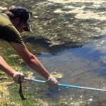
The Selkirk students will learn about measuring flow using the salt dilution gauging methodology that is used on all of the KWS project’s streams. The method involves adding a small amount of salt to a stream and recording the change in conductivity of the stream over time as the salty water moves down the channel. By processing the recorded conductivity data, students can calculate the flow in litres per second. This methodology is well-adapted for steep mountain streams where other methods are less reliable.
This spring, the KWS team and volunteers are gearing up to get out to the project’s hydrometric sites to download the winter data and make sure everything is ready in place to catch the spring freshet flows. Flow will be measured at all our sites to improve our ability to accurately calculate streamflow (Litres/second) from the automated stream depth (meters) measurements that our systems record every 15 minutes in the stream.
KWS Data Available Online
Our data is now available online:
- Aquarius WebPortal – A big shout out to our amazing partner Aquatic Informatics.
- Columbia Basin Water Hub – The open source database and repository for all water-related data in the Columbia Basin.
Questions? Contact KWS Program Manager Mark Elder: mark@livinglakescanada.ca or Program Hydrologist Paul Saso: paul@livinglakescanada.ca
